This ROAD GUIDE is issued for reference only, It is not intented to be the Official numbering or equipment routing directory of any Fire Dept. or Life Squad. The author maintains no responsibility for corrections or errors of this ROAD GUIDE!


CINCINNATI-COLUMBUS ROAD SOUTH
Take US.42 SOUTH from Waynesville for .7 of a mile, turn RIGHT onto Lower-Springboro Rd. and you run into Cincinnati-Columbus Road South.
6000 to 5000 from NORTH END to SOUTH END.
Top of Page
CLARKSVILLE ROAD
Take SR. 73 EAST from Waynesville for 1.1 miles to Clarksville Rd.
TURN LEFT FOR:
6000N to 6349N from SR.73 to Corwin's Corp. Line
133 to 31 from Corp. Line to Corwin Ave.
TURN RIGHT FOR:
5999N to 4000N from SR.73 to DAM, it changes into Lincoln Rd. 4000 to 2800 Turn LEFT at Oregonia Rd. go 2 miles & pick up Clarksville Rd. again on the RIGHT.
3719N to 3000N from Oregonia Rd. to Huddleson Rd.
3000N to 1600N from Huddleson Rd. to I-71.
1600N to 0000N from I-71 to US. 22-3.
Top of Page
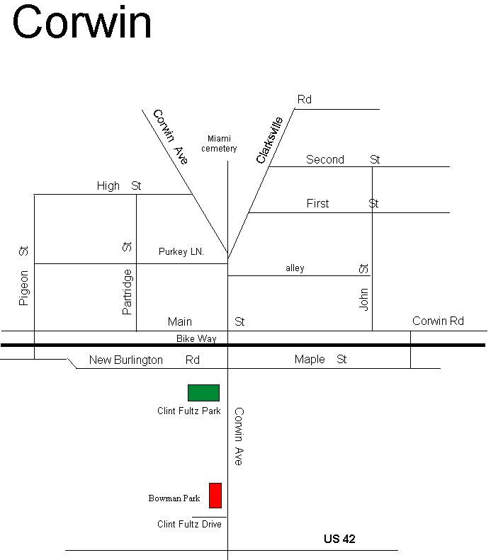
CLINT FULTZ DRIVE
Take US 42 to Corwin Ave Clint Fultz Drive will be on your LEFT.
Top of Page
COLD SPRING LANE
Take New Burlington Rd. to Wilson Rd., to Sandy Run Drive , turn LEFT onto Sandy Run Drive, Cold Spring Lane will be the 4th street on your LEFT.
Top of Page
COLLETT ROAD
Take US.42 NORTH from Waynesville for 6 miles to Roxanna-New Burlington Road. Then take Roxanna-New Burlington Rd. to Pence-Jones Rd., Collett Rd. bares to the RIGHT off of Pence-Jones Rd.
10000 to 9000 from Pence-Jones Rd. past Trailer Park to DEAD END.
Top of Page
COMPTON ROAD
Take New Burlington Rd. NORTH and go past Wilson Rd. and it runs into Compton Rd.
8000 to 10000 from New Burlington Rd. to Roxanna-New Burlington Rd.
Top of Page
COOK-JONES ROAD
Take US.42 NORTH from Waynesville for 3.6 miles to Cook-Jones Rd. Turn LEFT off of US.42 onto Cook-Jones Rd.
8200 to 6500 from US.42 to Old Stage Road.
Top of Page
FAIRFIELD DRIVE
Take Corwin Rd. SOUTH past O'Neall Rd. to Morris Ave. Turn LEFT onto Morris Ave. to Fairfield Drive.
5668 to 5800 turn LEFT onto Fairfield Drive.
5668 to 5539 turn RIGHT onto Fairfield Drive.
Top of Page
FERRY ROAD
Take Lytle Rd. NORTH for 1.1 miles and you run into Ferry Rd. at the 3-WAY STOP.
8200 to 8908 from Lytle Rd. to Haines Rd.
8908 to 9834 from Haines Rd. to the Greene County Line.
Top of Page
FLAT FORK RIDGE
Take Clarksville Rd. and go over the DAM at Caesar Creek Lake and the drive to the LEFT past the DAM is the FLAT FORK RIDGE picnic area and overlook with hiking trails.
Top of Page
FORGE DR. (Furnas Forge Subsivison)
Take US.42 North 1 block, turn RIGHT onto Corwin Ave. Go past the Miami Cematary TURN LEFT onto Balladier Blvd. Turn LEFT onto SunRidge Dr.. Go past Anvil Dr. Forge Dr. will be on your RIGHT.
Top of Page
FURNAS-OGLESBY ROAD
Take SR.73 EAST past Clarksville Rd. and the second road on the LEFT past Clarksville Rd. is Furnas-Oglesby Rd.
6028 to 7200 from SR.73 to the curve past access road that goes to the saddle dam.
7200 to 7800 from curve past access road to New Burlington Rd.
NOTE: There is a State Horse Camp and bridal paths about 7300 and our map shows it as Furnas Rd.
Top of Page
FURNAS SHORE BOAT DOCK (SR.73)
Take SR.73 EAST of Waynesville for 3.5 miles and just as you get on the 4 lane highway on your RIGHT is the ENTRANCE to the Furnas Shore Boat Dock or 73 boat dock.
Top of Page
GARD ROAD
Take U.S 42 SOUTH to Waynesville Rd. Take Waynesville Rd. until you come to Middletown Rd. Turn LEFT and cross over the covered bridge on Middletown Rd. Then turn RIGHT onto Corwin Rd. to the first road on the LEFT, which is Elbon Rd. this will run into Gard Rd.
5900 to 7000 turn LEFT onto Gard Rd. to O'Neall Rd.
5900 to 5100 turn RIGHT onto Gard Rd. to Corwin Rd.
NOTE: or you can go on past Elbon Rd. on Corwin Rd. and the next road on the LEFT is Gard Rd. Going up the hill is very STEEP.
5100 to 5900 from Corwin Rd. to Elbon Rd.
5900 to 7000 from Elbon Rd. to O'Neall Rd.
Top of Page
GRACE LANE
Take Lytle Rd. to Lytle-Ferry Rd. Turn RIGHT onto Lytle-Ferry Rd. and Grace Lane will be the first road on your LEFT.
Top of Page
HACKER FARM LANE
Take Lytle Rd. to Lytle, go thru Lytle too Lytle-Five Points Rd. Go .7 mile on Lytle- Five Points Rd. and at the curve, turn RIGHT onto Kenrick Rd. Hacker Farm Lane will be on the RIGHT off of Kenrick Rd. 9000 to 10000 from Kenrick Rd. to DEAD END.
Top of Page
HAINES ROAD
Take Lytle Rd. NORTH to Ferry Rd., go .8 mile on Ferry Rd. and Haines Rd. is on your RIGHT.
8900 to 10000 from Ferry Rd. to the Greene County Line.
NOTE: Haines Rd. and Haines Rd. Boat Dock are not the same, they are miles apart!
Top of Page
HAINES ROAD BOAT DOCK
Take New Burlington Rd. NORTH past Wilson Rd. to Compton Rd. Turn RIGHT onto Haines Rd. off of Compton Rd. and you run into the Haines Road Boat Dock.
10800 to 11000 from Compton Rd. to the boat dock.
NOTE: Haines Rd. and Haines Rd. Boat Dock are not the same, they are miles apart!
Top of Page
HARLAN-CARROLL ROAD
Take SR.73 EAST to Harveysburg and turn RIGHT onto Oregonia Rd. Go past Brooks-Carroll Rd. you run into Harlan-Carroll Rd. at the curve. 4000 to 2000 from Oregonia Rd. to Harveysburg Rd.
Top of Page
HARVEYSBURG ROAD
Take SR.73 EAST to Harveysburg. Next road past Oregonia Rd. is Harveysburg Rd. 5100 to 5800 turn LEFT from SR.73 to the lake. 5100 to 4100 turn RIGHT from SR.73 to Brooks-Carroll Rd. 4100 to 2700 from Brooks-Carroll Rd. to Levicy Rd. 2700 to 2133 from Levicy Rd. to South side of I-71. 2133 to 1300 from South side of I-71 to Wilmington Rd.
Top of Page
HENDERSON ROAD
Take Old Stage Rd. to Bellbrook Rd. and the first road before Chenoweth Rd. is Henderson Rd.
Top of Page
HOPEWELL DAY LODGE
Take Clarksville Rd. to Middletown Rd. and turn LEFT and you go to the Hopewell Day Lodge and picnic area. There is also a pond on your LEFT before you get to the Lodge.
Top of Page
HUDDLESON ROAD
Take Clarksville Rd. to Oregonia Rd. turn LEFT onto Oregonia Rd. until you come to Clarksville Rd. again. Turn RIGHT onto Clarksville Rd. and the first road on the LEFT is Huddleson Rd. 9000 to 9600 from Clarksville Rd. to Harlan-Carroll Rd.
Top of Page
